
Saturday, 20 February 2016
Tuesday, 9 February 2016
Guerrilla Celestial Navigation
Probably not too different from what blue water navigators have had to do to catch a sight and determine a fix - I coin the term Guerrilla Celestial Navigation not so much as replicating or performing to an art form but to do what you might have to do to the best of your abilities or circumstances - to get the job done.
I have used the same term when making sushi at home - the art form is not practiced just the raw production of most times very tasty sushi.
So what constitutes Guerrilla Celestial Navigation? Here goes...
- taking a sun sight against a near shore horizon because that is all you have
- waiting for an opening in the cloud cover to get a sun sight while you can before losing it to the next cloud
- catching a sun sight when you have light cloud cover
- trying to guess where the limb of the sun is during an obscured sight
Take what you can when you have it - while you have it.
Tuesday, 2 February 2016
Worksheet and Tables vs. StarPilot TI 89 Calculator
For the past few days I have been working with the StarPilot TI 89 Calculator and comparing process and results. The plan to work with the calculator was to keep working to find a quick and accurate way to process sights so that while on a boat under varying conditions I could develop an accurate fix in as brief a processing period possible - for the purpose of continuing to develop the toolkit towards an 'acoustic' and practical approach to Celestial Navigation.
I don't want to see myself spending 15 to 30 minutes determining a fix, while thumbing through multiple tables, making mistakes and getting sea sick while below.
All sights were taken with a Davis Mark 25 plastic sextant through an artificial horizon - under near perfect viewing conditions. All sights were taken at local time and adjusted for watch error. Each sight session consisted of 3 sights and averaged.
All worksheet sights were reduced via Pub 249 Vol 3 Tables.
From the following:
Course and Speed: 000d 0Kn (Stone Frigate)
Actual Position: N43d43.0' W079d24.0'
DR: N43d W079d
Date: 1 Feb 2016
Sight #1 Sun UL
UTC = 15:50:09
Hs = 25d16.8'
Lon AP = 079d09.7'
Sight #2 Sun LL
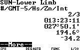
UTC = 18:23:11
Hs = 27d50.1'
Lon AP = 079d24.9'
Sight #3 Sun LL
UTC = 20:10:15
Hs = 19d00.1'
The results: Worksheet StarPilot
Sight #1 Zn = 153d T Zn = 153.5d T
Int = 39' A Int = 42.3 A

Sight #2 Zn = 194d T Zn = 194.6d T
Int = 38' A Int = 34.2 A
Sight #3 Zn = 221d T Zn = 220.9d T
Int = 21' A Int = 16.6' A

Fix N 43d 38.0' N 43d 38.9'
W 079d 27.0' W 079d 24.9'

Accuracy within 7 nm within 5 nm

With StarPilot...
- DR is the AP
- a bit more accurate
- takes about 2 minutes versus 15 to 20 minutes to determine a fix
- keep spare batteries and sea water out - no solar power
Clearly the Starpilot approach is very accurate and very quick to produce a fix and I can't wait to do the real thing on the water.
Here are the Worksheets and the Plot...
I don't want to see myself spending 15 to 30 minutes determining a fix, while thumbing through multiple tables, making mistakes and getting sea sick while below.
All sights were taken with a Davis Mark 25 plastic sextant through an artificial horizon - under near perfect viewing conditions. All sights were taken at local time and adjusted for watch error. Each sight session consisted of 3 sights and averaged.
All worksheet sights were reduced via Pub 249 Vol 3 Tables.
From the following:
Course and Speed: 000d 0Kn (Stone Frigate)
Actual Position: N43d43.0' W079d24.0'
DR: N43d W079d
Date: 1 Feb 2016
Sight #1 Sun UL
UTC = 15:50:09
Hs = 25d16.8'
Lon AP = 079d09.7'
Sight #2 Sun LL
UTC = 18:23:11
Hs = 27d50.1'
Lon AP = 079d24.9'
Sight #3 Sun LL
UTC = 20:10:15
Hs = 19d00.1'
The results: Worksheet StarPilot
Sight #1 Zn = 153d T Zn = 153.5d T
Int = 39' A Int = 42.3 A

Sight #2 Zn = 194d T Zn = 194.6d T
Int = 38' A Int = 34.2 A

Sight #3 Zn = 221d T Zn = 220.9d T
Int = 21' A Int = 16.6' A

Fix N 43d 38.0' N 43d 38.9'
W 079d 27.0' W 079d 24.9'

Accuracy within 7 nm within 5 nm

With StarPilot...
- DR is the AP
- a bit more accurate
- takes about 2 minutes versus 15 to 20 minutes to determine a fix
- keep spare batteries and sea water out - no solar power
Clearly the Starpilot approach is very accurate and very quick to produce a fix and I can't wait to do the real thing on the water.
Here are the Worksheets and the Plot...
 |
| Sun Sight #1 |
 |
| Sun Sight #2 |
 |
| Sun Sight #3 |
 |
| Plotting Sheet Comparing Worksheet and StarPilot (in Red) |
Subscribe to:
Comments (Atom)